![](/images/other/stat-length.png)
![Trail Walking Le Dévoluy - Cabane de la Rama - Photo](https://media.geolcdn.com/t/1900/400/ext.pjpeg?maxdim=2&url=https%3A%2F%2Fmedia.geolcdn.com%2Ff%2F64d68da8-e0f7-42f5-a12c-f9139da8a866.jpg)
Cabane de la Rama
Marco05
User
![Length](/images/other/stat-length.png)
Length
5.8 km
![Max alt](https://static1.geolcdn.com/siteimages/upload/files/1508320355ic_sort_altitude_max_24dp.png)
Max alt
1576 m
![Uphill gradient](https://static1.geolcdn.com/siteimages/upload/files/1508320355ic_sort_den_pos_24dp.png)
Uphill gradient
210 m
![Km-Effort](/images/other/stat-length.png)
Km-Effort
8.6 km
![Min alt](https://static1.geolcdn.com/siteimages/upload/files/1508320355ic_sort_altitude_min_24dp.png)
Min alt
1383 m
![Downhill gradient](https://static1.geolcdn.com/siteimages/upload/files/1508320355ic_sort_den_neg_24dp.png)
Downhill gradient
210 m
![Boucle](https://static1.geolcdn.com/siteimages/upload/files/16400158638029165_repeat_loop_refresh_sync_direction_icon.png)
Boucle
Yes
Creation date :
2022-03-26 10:47:21.04
Updated on :
2022-08-06 12:21:25.391
![Walking](https://static1.geolcdn.com/sitytour/trail-icons/101.png)
1h56
Difficulty : Easy
![Scan this QR Code to open this trail in the SityTrail application](https://capi.geolives.com/qq0zvz2zws4bq2lad0pu/sitytour/trails/3181019/qr.png?size=200)
FREE GPS app for hiking
About
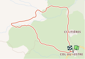
Trail Walking of 5.8 km to be discovered at Provence-Alpes-Côte d'Azur, Hautes-Alpes, Le Dévoluy. This trail is proposed by Marco05.
Description
Petite promenade facile au départ du col de Festre.
Pas un gros dénivelé, et pas de passage aérien.
Très bien pour débuter dans les randonnées de montagne.
Positioning
Country:
France
Region :
Provence-Alpes-Côte d'Azur
Department/Province :
Hautes-Alpes
Municipality :
Le Dévoluy
Location:
Agnières-en-Dévoluy
Start:(Dec)
Start:(UTM)
726543 ; 4949904 (31T) N.
Comments
Trails nearby
![Trail Walking Le Dévoluy - R13 Le Col de Lauteret - Photo](https://media.geolcdn.com/t/375/260/ext.jpg?maxdim=2&url=https%3A%2F%2Fservices.sitytrail.com%2FGeolivesWS%2FDownloadMedia.ashx%3FTrailID%3D890869%26Media%3D3ddec85f-ff9e-4fa0-b708-df941654a773.jpg)
![Walking Walking](https://static1.geolcdn.com/sitytour/trail-icons/101.png)
R13 Le Col de Lauteret
Walking
Medium
(1)
Le Dévoluy,
Provence-Alpes-Côte d'Azur,
Hautes-Alpes,
France
![](/images/other/stat-length.png)
8.5 km | 15.9 km-effort
3h 12min
![](https://static1.geolcdn.com/siteimages/upload/files/16400158638029165_repeat_loop_refresh_sync_direction_icon.png)
Yes
![Trail Walking Le Dévoluy - R12 Le Col des Aiguilles - Photo](https://media.geolcdn.com/t/375/260/ext.jpg?maxdim=2&url=https%3A%2F%2Fservices.sitytrail.com%2FGeolivesWS%2FDownloadMedia.ashx%3FTrailID%3D890868%26Media%3Da17a685b-d707-4ec8-9ad3-ca551d593978.jpg)
![Walking Walking](https://static1.geolcdn.com/sitytour/trail-icons/101.png)
R12 Le Col des Aiguilles
Walking
Medium
(1)
Le Dévoluy,
Provence-Alpes-Côte d'Azur,
Hautes-Alpes,
France
![](/images/other/stat-length.png)
10.2 km | 19.2 km-effort
3h 56min
![](https://static1.geolcdn.com/siteimages/upload/files/16400158638029165_repeat_loop_refresh_sync_direction_icon.png)
Yes
![Trail Walking Le Dévoluy - R11 Cabane Rama - Photo](https://media.geolcdn.com/t/375/260/ext.jpg?maxdim=2&url=https%3A%2F%2Fservices.sitytrail.com%2FGeolivesWS%2FDownloadMedia.ashx%3FTrailID%3D890866%26Media%3D15965f3b-d395-4eb7-8005-d43c93878ecf.jpg)
![Walking Walking](https://static1.geolcdn.com/sitytour/trail-icons/101.png)
R11 Cabane Rama
Walking
Very easy
(4)
Le Dévoluy,
Provence-Alpes-Côte d'Azur,
Hautes-Alpes,
France
![](/images/other/stat-length.png)
5.5 km | 8.4 km-effort
1h 46min
![](https://static1.geolcdn.com/siteimages/upload/files/16400158638029165_repeat_loop_refresh_sync_direction_icon.png)
Yes
![Trail Walking Le Dévoluy - Cascade de Saute Aure - Photo](https://media.geolcdn.com/t/375/260/ext.jpg?maxdim=2&url=https%3A%2F%2Fservices.sitytrail.com%2FGeolivesWS%2FDownloadMedia.ashx%3FTrailID%3D206042%26Media%3Dfix__20130719142756.jpg)
![Walking Walking](https://static1.geolcdn.com/sitytour/trail-icons/101.png)
Cascade de Saute Aure
Walking
Easy
(3)
Le Dévoluy,
Provence-Alpes-Côte d'Azur,
Hautes-Alpes,
France
![](/images/other/stat-length.png)
7.7 km | 10.8 km-effort
3h 1min
![](https://static1.geolcdn.com/siteimages/upload/files/16400158638029165_repeat_loop_refresh_sync_direction_icon.png)
Yes
![Trail Running Le Dévoluy - Trail 02 - Le Chauvet par le vallon des Aiguilles - Photo](https://media.geolcdn.com/t/375/260/ext.jpg?maxdim=2&url=https%3A%2F%2Fmedia.geolcdn.com%2Ff%2F7d9b2dd1-9a3f-4948-aa7e-d2465674126c.jpg)
![Running Running](https://static1.geolcdn.com/sitytour/trail-icons/103.png)
Trail 02 - Le Chauvet par le vallon des Aiguilles
Running
Difficult
Le Dévoluy,
Provence-Alpes-Côte d'Azur,
Hautes-Alpes,
France
![](/images/other/stat-length.png)
8.3 km | 17.1 km-effort
1h 30min
![](https://static1.geolcdn.com/siteimages/upload/files/16400158638029165_repeat_loop_refresh_sync_direction_icon.png)
Yes
![Trail Mountain bike Le Dévoluy - VTT16 - Boudelle - Photo](https://media.geolcdn.com/t/375/260/ext.jpg?maxdim=2&url=https%3A%2F%2Fservices.sitytrail.com%2FGeolivesWS%2FDownloadMedia.ashx%3FTrailID%3D901643%26Media%3D630c826d-57ee-4538-8d59-b504d2c60286.jpg)
![Mountain bike Mountain bike](https://static1.geolcdn.com/sitytour/trail-icons/202.png)
VTT16 - Boudelle
Mountain bike
Difficult
Le Dévoluy,
Provence-Alpes-Côte d'Azur,
Hautes-Alpes,
France
![](/images/other/stat-length.png)
18.9 km | 30 km-effort
1h 51min
![](https://static1.geolcdn.com/siteimages/upload/files/16400158638029165_repeat_loop_refresh_sync_direction_icon.png)
Yes
![Trail Walking Le Dévoluy - R21 L'observatoire de Bure depuis la Joue du Loup - Photo](https://media.geolcdn.com/t/375/260/ext.jpg?maxdim=2&url=https%3A%2F%2Fservices.sitytrail.com%2FGeolivesWS%2FDownloadMedia.ashx%3FTrailID%3D890878%26Media%3D41c054bd-a36e-42bf-b19f-1062421a5645.jpg)
![Walking Walking](https://static1.geolcdn.com/sitytour/trail-icons/101.png)
R21 L'observatoire de Bure depuis la Joue du Loup
Walking
Difficult
Le Dévoluy,
Provence-Alpes-Côte d'Azur,
Hautes-Alpes,
France
![](/images/other/stat-length.png)
11.9 km | 21 km-effort
4h 21min
![](https://static1.geolcdn.com/siteimages/upload/files/16400158638029165_repeat_loop_refresh_sync_direction_icon.png)
Yes
![Trail Walking Le Dévoluy - Vallons des Adroits et Girier Via Lachap - Photo](https://media.geolcdn.com/t/375/260/ext.jpg?maxdim=2&url=https%3A%2F%2Fmedia.geolcdn.com%2Ff%2F910890d2-ec2f-480b-aac5-c944dd6fd877.jpg)
![Walking Walking](https://static1.geolcdn.com/sitytour/trail-icons/101.png)
Vallons des Adroits et Girier Via Lachap
Walking
Very difficult
Le Dévoluy,
Provence-Alpes-Côte d'Azur,
Hautes-Alpes,
France
![](/images/other/stat-length.png)
12.1 km | 23 km-effort
5h 9min
![](https://static1.geolcdn.com/siteimages/upload/files/16400158638029165_repeat_loop_refresh_sync_direction_icon.png)
Yes
![Trail Walking Le Dévoluy - suuntoapp-Hiking-2024-06-17T07-23-45Z - Photo](https://media.geolcdn.com/t/375/260/ext.jpg?maxdim=2&url=https%3A%2F%2Fmedia.geolcdn.com%2Ff%2F1d5aff52-7442-421b-9399-0de1c57b8c1c.jpg)
![Walking Walking](https://static1.geolcdn.com/sitytour/trail-icons/101.png)
suuntoapp-Hiking-2024-06-17T07-23-45Z
Walking
Difficult
Le Dévoluy,
Provence-Alpes-Côte d'Azur,
Hautes-Alpes,
France
![](/images/other/stat-length.png)
9.6 km | 17.9 km-effort
4h 4min
![](https://static1.geolcdn.com/siteimages/upload/files/16400158638029165_repeat_loop_refresh_sync_direction_icon.png)
Yes